Rhodes Park
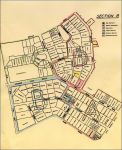
This is a map that covers part of the Rhodes Park area in Lusaka.
It was drawn up in the early 60's and was used for armed night patrols when trouble was expected leading up to independence, trouble that never materialised.
The map shows the boundaries of all the properties with the surname of the people living there at the time.
It covers a area between The Great East Road and Cecil Rhodes Drive.
Facebook Social Comments
